


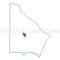
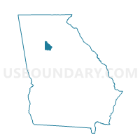
089RG - ROWLAND ELEM Voting District, DeKalb County, Georgia
About
Outline

Summary
| Unique Area Identifier | 561075 |
| Name | 089RG - ROWLAND ELEM Voting District |
| County | DeKalb County |
| State | Georgia |
| Area (square miles) | 1.71 |
| Land Area (square miles) | 1.70 |
| Water Area (square miles) | 0.01 |
| % of Land Area | 99.59 |
| % of Water Area | 0.41 |
| Latitude of the Internal Point | 33.76315640 |
| Longtitude of the Internal Point | -84.23297900 |
Maps

Graphs
Select a template below for downloading or customizing gragh for 089RG - ROWLAND ELEM Voting District, DeKalb County, Georgia


Neighbors
Neighoring Voting District (by Name) Neighboring Voting District on the Map
- 089AA - ALLGOOD ELEMENTARY Voting District, DeKalb County, GA
- 089AC - ATHERTON ELEMENTARY Voting District, DeKalb County, GA
- 089AM - AVONDALE MIDDLE Voting District, DeKalb County, GA
- 089CT - COVINGTON HWY L Voting District, DeKalb County, GA
- 089DE - DUNAIRE ELEM Voting District, DeKalb County, GA
- 089GB - GLENHAVEN Voting District, DeKalb County, GA
- 089GE - GLENHAVEN ELEM Voting District, DeKalb County, GA
- 089PA - PEACHCREST ELEM Voting District, DeKalb County, GA
- 089RJ - ROWLAND ROAD Voting District, DeKalb County, GA
Top 10 Neighboring County Subdivision (by Population) Neighboring County Subdivision on the Map
Top 10 Neighboring Place (by Population) Neighboring Place on the Map
Top 10 Neighboring Unified School District (by Population) Neighboring Unified School District on the Map
Top 10 Neighboring State Legislative District Lower Chamber (by Population) Neighboring State Legislative District Lower Chamber on the Map
- State House District 87, GA (41,980)
- State House District 86, GA (40,885)
- State House District 89, GA (40,729)
- State House District 85, GA (40,501)
Top 10 Neighboring State Legislative District Upper Chamber (by Population) Neighboring State Legislative District Upper Chamber on the Map
- State Senate District 43, GA (177,093)
- State Senate District 55, GA (158,179)
- State Senate District 42, GA (147,006)
Top 10 Neighboring 111th Congressional District (by Population) Neighboring 111th Congressional District on the Map
Top 10 Neighboring Census Tract (by Population) Neighboring Census Tract on the Map
- Census Tract 232.06, DeKalb County, GA (7,211)
- Census Tract 232.04, DeKalb County, GA (6,602)
- Census Tract 231.07, DeKalb County, GA (4,452)
- Census Tract 231.08, DeKalb County, GA (4,241)
- Census Tract 231.12, DeKalb County, GA (3,991)
- Census Tract 231.15, DeKalb County, GA (3,228)
- Census Tract 231.14, DeKalb County, GA (2,434)
- Census Tract 231.11, DeKalb County, GA (1,590)